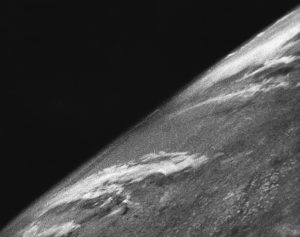
Since Bill Clinton allowed the private industries to use satellite imagery in 1994 Private satellite imagery sector is growing rapidly [1]. First satellite image was taken October 24, 1946, it was an image of the earth [2].
At the beginning satellite imagery served as military surveillance purposes, but now it serves for several purposes especially scientific research, journalism, and the humanitarian aid and rescue sector among others. Satellite imagery provide a unique space-eye images of locations on earth that can be interpreted to extract and understand data and situations, Artificial intelligence (AI) help to expedite the interpretation and extract further data, and Machine learning (ML) help to develop and further expedite AI’s interpretation. Millions of satellite images are taken daily. The images taken by the satellite are of a huge area of earth and huge in file size with low resolution. Satellite imageries are main civic uses of that the aid and rescue works can benefit from are to generate maps of the world, monitoring population displacement, providing images of disastrous area to help the rescue works, settlement mapping (Figure), deforestation, dissertation, drought. Famine, environmental pollution tracking and anticipation, agriculture and forestry, weather forecasting to anticipate and track disasters such as hurricanes, and tracking forest fires [3]. Satellite imagery is directly benefitting NGOs by easily visualizing areas impacted by a natural disaster, for example, and organizing their response while quickly assessing the local situation, verifying the road conditions, and planning rescue activities accordingly. As the NGOs also have the possibility to task (Tasking may include the launch and/or positioning the satellite in a specific orbit or monitor a specific area). our satellites for specific area coverage, they can receive new images when needed and compare them with older ones: for instance, to track movements of refugees, in monitoring the impact of river flooding and seeing the effects of drought [4]. There are several private commercial providers of satellite imagery the mostly known are Maxar, black sky, planet labs from the USA, Airbus from France, Imagesat International an Israeli company. While most common free open-source providers are Google, Sentinel Hub, Zoom Earth, World Imagery Wayback. A lot of technical concerns are involved in the use of satellite imagery due to the complexity of the specification and parameters that affect those specification of the image file for example, the spatial resolution of the image which is between 0,3-1,5m per pixel depending on the source, frequency of images to the same area ranging from hours to two years ,the weather condition is it cloudy, snow, rain, sand storm, etc. time of the day is it night or day, sun position and angle, the angel of the camera to the surface of earth. And so on.
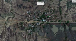
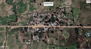
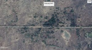
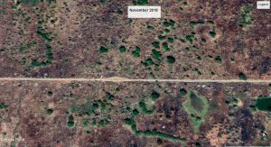
Another important aspect is the fact that satellite imagery is not real-time images, hence it is used only for comparison mostly. An example is the following images of an abandoned village in northwest of Nigeria using google earth desktop version.
Finally the consideration of the ethical aspects of taking and using satellite imagery and as a controversial example the case when on February 2003, UN security council Colin Powell used the satellite images of alleged weapons of mass destruction [1].
References